Bonding Thru Struggle

Japanese Invasion of Philippines created the Second Philippine Republic, sponsored by the Japanese as a conquering force of WWII. This war broke out one month after re-election of Second Philippine President Manuel Luis Quezon, whose government-in exile was formed in Corregidor, with U.S. military advisor General Douglas MacArthur. Together they witnessed the heroic yet doomed stand made by the combined Filipino-American forces against invading Japanese. Ultimately President Quezon and his family would be moved to Washington, D.C. USA.
Japan fully captured the Philippines on May 6, 1942, after the Battle of Corregidor. General Masaharu Homma decreed the dissolution of the Commonwealth of the Philippines and established the Philippine Executive Commission, a caretaker government with Jorge B. Vargas as its first chairman, in January 1942.

While in exile from Philippines, Quezon gave speeches before the U.S. Congress and elsewhere reminding the American people of the Philippine people’s plight, their loyalty to the United States, and advocating for their early liberty. Quezon’s second term as president was supposed to expire in mid-November 1943, but he desperately wanted to stay on, perhaps until the time he could see through the country’s liberation from the clutches of the Japanese. Upon his insistence, the US Congress passed Joint Resolution No. 25 extending his and the vice president’s terms of office indefinitely until constitutional process and normal functions of government have been restored in Philippines. President Quezon died in August 1944, less than three months before MacArthur’s dramatic return to Philippine soil.
[1]Stewards of the Nation,
Previously the USA had approved a ten-year transition plan in 1934 and drafted a new constitution in 1935. This constitution featured a political system virtually identical to the American one calling for a President to be elected at large for a 4-year term (subject to one re-election), a bicameral Congress, and an independent Judiciary. Philippine independence was eventually achieved on July 4, 1946.
From Constitutionnet.org:
From the moment of independence, Filipino politics have been plagued by the twin demons of corruption and scandal. Notwithstanding, Presidents Ramon Magsaysay (1953-57), Carlos Garcia (1957-61), and Diosdado Macapagal (1961-65) managed to stabilize the country, implement domestic reforms, diversify the economy, and build Philippine ties not only to the United States, but also to its Asian neighbours.
[2]Constitional history of the Phiippines, Constitutionnet.org:
5,000+ Miles Away The ALCAN Highway Proposed to Provide Wartime Support

On February 6, 1942, construction of the Alaska-Canada (Alcan) Highway was approved by the United States Army.The project received authorization from the U.S. Congress and President Franklin D. Roosevelt to proceed five days later. Always fair-weather friends, Canada agreed to allow construction as long as the United States bore the full cost, and the road and other facilities in Canada be turned over to Canadian authority after the war ended.
[3]Construction of the Alcan Highway in 1942
Thus began a massive construction project, the official start of which took place on March 9, 1942, after hundreds of pieces of construction equipment were moved on priority trains by the Northern Alberta Railways to the northeastern part of British Columbia near Mile 0 at Dawson Creek.
When completed in 1942, the Alcan was about 2,700 kilometers (1,700 mi) long. This amazing wartime effort was completed in eight month 12 days, on November 21, but was not usable by general vehicles until 1943. Despite building this initial rough road, most supplies to Alaska during the war were sent by sea from San Francisco, Seattle, and Prince Rupert.

The content below was originally paywalled.

The Alcan Highway opened to the public in 1948. This writer has driven it numerous times–even hitch-hiking with a girlfriend from Anchorage to New York state and back in 1976. By 2012, the Alcan Highway was only 2,232 km (1,387 mi) due to continuing reconstruction to reroute and straighten many sections. Once legendary for being a rough, challenging drive, the highway is now paved over its entire length and can be very enjoyable any time of year.
Throughout this time Filipinos have also become an important presence in Alaska, before and since statehood. More than ever Alaska’s small population is a welcoming place for Asian people.
Alaska’s Strategic Location Today

Alaska is the most strategic place on earth, stated Brig. Gen. Billy Mitchell in testimony before Congress in 1935
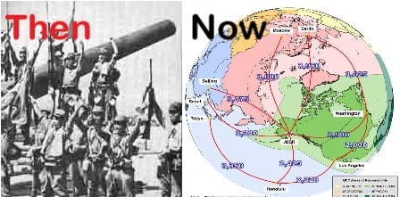
[4]The Thousand-Mile War
This bold statement can be made because–as the above graphic shows–Alaska is the closest U.S. location to the center of the Northern Hemisphere. Alaska is closer to many national capitals in the hemisphere than most points in the lower forty-eight states. This makes Alaska the perfect power projection platform for the United States from a military standpoint. Further, because Alaska sits astride the Bering Strait choke-point and the Great Circle Routes between North America and Asia, as shown in graphic 2, it is critical to economic and national security of USA.

[5]Armyupress.army.mil

Alaska’s strategic global location is between the two largest countries in the World; Russia and Canada. Americans wishing to reach Alaska must cross another country’s air or terrestrial space. Most Asians can fly directly here.
[6]Largest 10 countries in the world by area.
As strong international allies the USA and Philippines have shared a history of East><West challenges but managed to face down adversaries for mutual benefit. In today’s modern world Alaska’s location places the state and country at the center of this fast-evolving region and we need each other more than ever.
[7]The world’s busiest airport on some days.
References:
[1]Stewards of the Nation, J. Eduardo Malaya & Jonathan E. Malaya, ANVIL Publishing, Inc.,(www.anvilpublishing.com), 2018 P-51.
[2]Constitional history of the Phiippines, Constitutionnet.org:
[3]Construction of the Alcan Highway in 1942
[4]The Thousand-Mile War
Brian Garfield,The Thousand Mile War: World War II in Alaska and the Aleutians(1969; repr., Fairbanks, AK: University of Alaska Press, 1995), 59.
[5]armyupress.army.mil
https://www.armyupress.army.mil/Journals/Military-Review/English-Edition-Archives/January-February-2018/Why-Alaska-and-the-Arctic-are-Critical-to-the-National-Security-of-the-United-States/
[6]The 10 Largest Countries on Earth
The largest country in the world is Russiawith a total area of 17,098,242 Km² (6,601,665 mi²) and a land area of 16,376,870 Km² (6,323,142 mi²), equivalent to 11% of the total world’s landmass of 148,940,000 Km² (57,510,000 square miles). See also: Most Populous Countries.

[7]The world’s busiest airport,
https://edition.cnn.com/travel/article/anchorage-airport-world-busiest/index.html
Ted Stevens Anchorage International Airport has also become a primary international cargo hub, ranking in 2020 as the United States’ second-busiest airport, and the world’s fourth-busiest airport by cargo traffic. Cargo aircraft between China or Japan and the US prefer to refuel on the way to carry less fuel and more cargo.


